Stories
Mapping a Minneapolis Olympics
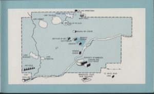
Published February 10, 2014 by Kirsten Delegard It’s map Monday. At the end of World War II, a group of Minneapolis businessmen formed the Olympic Invitation Committee of Minneapolis, which put together a bid to host the 1952 summer Olympics. The lovely brochure they printed in English, French and Spanish included this map, showing all…
Read MoreCastles and Homeopathy, 1892
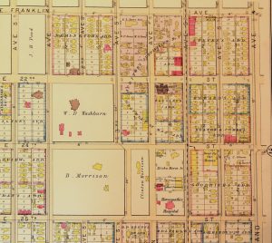
Published February 3, 2014 by Kirsten Delegard It’s map Monday. And here we have another plate from the 1892 C.M. Foote & Co real estate atlas. This page shows the blocks now occupied by the Minneapolis Institute of Arts and the Children’s Theater. When this map was made, this corner of the city was dominated…
Read MoreMinneapolis in 1948: ”Where in the heck do black people live around here?”
Published January 28, 2014 by Kirsten Delegard Matthew Little, civil rights leader, died this past Sunday at the age of 92. A leader of the Minnesota delegation of the 1963 March on Washington, Little was the long-time president of the Minnesota NAACP. He fought to open up hiring practices. He battled segregation in the state’s…
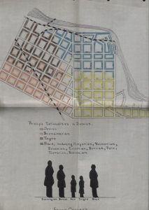
Read MoreMap Monday: Seven Corners in 1915
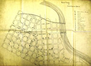
Published January 27, 2014 by Kirsten Delegard It’s Map Monday. Seven Corners librarian Grace Stevens drew this map to accompany her 1915 “Community Report,” a description of the Sixth Ward that surrounded her library building on Fifteenth Avenue South and Third Street. This small branch library had started as an experiment in 1906, the joint…
Read MoreNo tears for the Metrodome
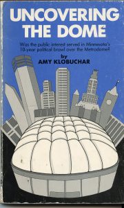
Published January 23, 2014 by Kirsten Delegard Few tears are being shed for the Metrodome, which was deflated today after three decades as a Minneapolis landmark. On the day of its demise it is interesting to revisit the contentious history of the marshmallow-like structure. In the 1970s, plans for a downtown sports dome mobilized opponents…
Read MoreIce Cream and Civil Rights: Fosters Sweet Shop on the 1920s Northside
Published January 15, 2014 by Kirsten Delegard Anthony B. Cassius remembers that the civil rights movement in Minnesota got started over ice cream in a modest North Minneapolis confectionary. In the early 1930s, a man named Herbert Howell, who worked for the African-American newspaper the Spokesman, “got us together and we formed what was known…
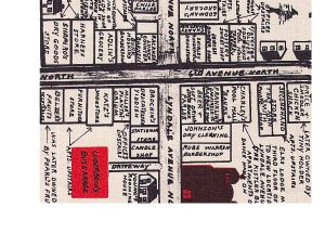
Read More“Variety is one thing we do not lack”: Seven Corners in 1917
Published January 13, 2014 by Kirsten Delegard It’s map Monday. This map of the Seven Corners neighborhood was created in 1917 by Minneapolis librarian Josephine M. McPike, who had been directed by her superiors to do a community study of the neighborhood surrounding her reading room at 300 Fifteenth Avenue South. In a style familiar…
Read MoreA guide to traveling “without embarassment”
Published January 13, 2014 by Kirsten Delegard More than a decade before Martin Luther King, Jr. delivered his legendary “I Have a Dream” speech, an African-American publisher named Victor H. Green articulated a modest vision for racial justice. “There will be a day sometime in the near future when this guide will not have to…
Read MoreWomen’s Hockey in the Jazz Age
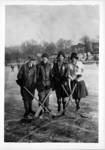
Published January 10, 2014 by Kirsten Delegard On January 10, 1926, these skaters on Lake of the Isles posed, smiling, with hockey sticks. Two of the players were women. This photo–along with many others from the decade–show that young women across the state were picking up sticks and enjoying recreational hockey match-ups. They were never…
Read MoreWhen Cedar-Riverside was “Snusgatan”
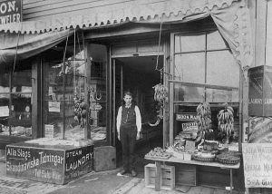
Published January 2, 2014 by Kirsten Delegard Minneapolitans love to reminisce about the counterculture years of the West Bank/Cedar Riverside neighborhood. But for most of the neighborhood’s history, small immigrant businesses like the Otanga grocery store–which was destroyed in yesterday’s fire–have dominated the commercial landscape. Here we have a photo from the 1890s that shows…
Read MoreR.I.P, 514 Cedar Avenue

Published January 1, 2014 by Kirsten Delegard Tragic news from the Cedar Riverside neighborhood, where 514 Cedar Avenue exploded this morning. At least 13 people were injured in the blaze; as of this writing, three people have not been found in the icy ruins. The building’s first floor contained a small grocery that catered to…
Read MoreCream of Wheat: Race and the Birth of the Packaged Food Industry in Minneapolis

Published December 17, 2013 by Kirsten Delegard At a moment when Minneapolis had a very small African American community, the city became home to “Rastus,” an iconic caricature of a black man. “Rastus” was the symbol of the Cream of Wheat company, which relocated to Minneapolis in 1897 from North Dakota. Over the next 100…
Read MoreTour the Chain of Lakes
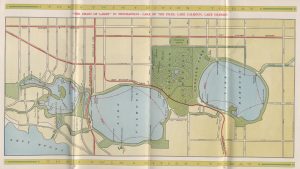
Published December 9, 2013 by Kirsten Delegard It’s map Monday. This 1913 map from the Twin Cities Transit company touts the attractions of Minneapolis of the city’s beloved chain of lakes. The red lines on the lakes trace the routes of the “launches” that circumnavigated Lake Harriet, Lake Calhoun and Lake of the Isles. “The…
Read MoreThe Murder of Walter Liggett
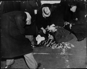
Published December 4, 2013 by Kirsten Delegard One of the crimes that prompted the “Murder in Minneapolis” map that I posted on Monday was the slaying of Walter W. Liggett, the radical publisher of the small Mid-West American. A couple of months before he was gunned down in the south Minneapolis alley behind his apartment,…
Read MoreMurder in Minneapolis, 1936

Published December 2, 2013 by Kirsten Delegard It’s map Monday. Published by the Chicago Tribune in 1936, this “Murder in Minneapolis” map was designed to illuminate “the Facts about a Crime-Ridden City.” Compiled as the city hit bottom, the diagram reflects the town’s unsavory reputation in 1936. Between the Teamsters’ strike of 1934 and 1946–when…
Read More“Betty Crocker Tours”: Minneapolis 540-2526

Published November 19, 2013 by Kirsten Delegard This advertisement invites anyone visiting Minneapolis to tour the kitchens of Betty Crocker, who was one of the best known and most admired American women in the years after World War II. Crocker was not a real woman. She was the fictional household expert fabricated to personify General…
Read MoreSchool Desegregation in Minneapolis

Published November 13, 2013 by Kirsten Delegard In November, 1970, the Minneapolis Public Schools announced a modest proposal meant to begin the desegregation of its schools. Aimed at undermining the effects of residential segregation in the city, it recognized that neighborhood schools were stratified by race. In the scheme announced by the School Board, two elementary…
Read MoreBohemian Flats
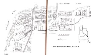
Published October 10, 2013 by Kirsten Delegard It’s map Monday. This map shows the Bohemian Flats in 1904, another lost world that is invisible to modern Minneapolitans. An ethnically-mixed enclave on the banks of the Mississippi River, the Bohemian Flats was a neighborhood of small houses and shanties constructed by new immigrants who were either…
Read MoreNewspaper Row: an “al fresco forum” on 4th Street

Published October 4, 2013 by Kirsten Delegard Long before the internet, before television and before radio, the media had a physical location in Minneapolis that everyone knew. Fourth Street was the “Fleet Street” for the local press. Newspaper row–which included the Globe, the Minneapolis Journal, the Pioneer Press, the Penny Press, the Tribune, the Minneapolis…
Read MoreWhy is it so hard to get a drink south of Lake Street?
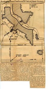
Published September 16, 2013 by Kirsten Delegard It’s map Monday. Ever wonder why it’s so hard to get a mixed drink south of Lake Street in Minneapolis? We can thank the historic “patrol limits,” which were incorporated into the city charter in the 1880s. The ordinance required bars and liquor stores to be concentrated in…
Read MoreStreetcars in Minneapolis: Now and Then
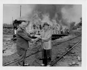
Published June 19, 2013 by Kirsten Delegard The city has decided to invest millions to build new streetcar lines. Which beggars the question, what happened to our old streetcar system? It met its demise in June of 1954, when this sinister-looking photo was taken. This image records the celebration organized by the Twin City Rapid…
Read MoreRacial Covenants
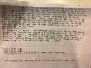
To enforce racial segregation in Minneapolis, real estate agents encouraged property owners to attach covenants to their property. Covenants like the one pictured here were incorporated into the property abstract. They bound property owners to not convey the property to anyone of “Chinese, Japanese, Moorish, Turkish, Negro, Monogolian or African blood or descent.” Many homes…
Read More